


1. Introduction
Proper solid waste management protects human health and the environment [1]. Both quantity and quality of generated municipal solid waste are changing with time due to influences of variable life styles and consumption behaviours [2, 3]. Municipal solid waste prediction is crucial for sustainable waste management. It is a key element for choosing and sizing waste disposal options [4, 5]. However, solid waste forecasting is a complex task due to influences of multiple factors that change with time [6]. As a result of rapid development, urbanization, increased per capita income, and consumption behaviours, solid waste generation has increased dramatically in Malaysia [7]. For instance, in 1998, the rate of solid waste generation was around 0.5 kg per capita per day. This rate has doubled within only ten years [8].
Time series forecasting uses past data to predict the future. Meanwhile, causal variable forecasting tries to find the relationship between the desired variable and other external variables [9]. Time series forecasting is a flexible technique. Its implementation does not require much data, and it is capable of catching fluctuations. The main limitation of using time series forecasting is the lack of empirical justifications [10]. However, time series forecasting does minimize the need for future estimations and data collection [11].
Recently, researchers have been developing different models to predict solid waste generation in Malaysia. However, these models are linear and [12–15]. The Autoregressive Integrated Moving Average (ARIMA) method, first presented by Box and Jenkin in 1976 [16], has been used in multiple environmental forecasting. For example, ARIMA was used to model solid waste generation in three areas in Spain and Greece [17]. Rimaityte et al. [2] concluded that ARIMA and seasonal exponential smoothing are the most accurate techniques to represent solid waste generation in fast developing economies.
However, landfill is considered to be the ultimate municipal solid waste disposal option. It is the preferred disposal choice in developing countries due to limitations of trained professionals and technologies [18]. Proper landfill siting is important to minimize the environmental and health impacts associated with its construction and operation [19]. Locating solid waste landfill belongs to Multi Criteria Decision Making (MCDM) analysis. It requires the assessment and analysis of a huge number of relevant factors and criteria that are not equal in importance and require different types of processing [20–23]. Most data analysis techniques divide the site selection task into smaller parts, and do the analysis and investigation for each one separately from the others parts. Finally, it aggregates them to locate the proper sites [24, 25]. These tasks are done using a combination of MCDM and Geographical Information Systems (GIS), which are widely used in locating facilities, due to their capability to manage and treat huge volumes of data [26]. However, to minimize the obstacles associated with landfill siting, like society opposition and data collection, it is important to properly estimate the required landfill area.
The Analytic Hierarchy Process (AHP) was introduced by Saaty. It handles both qualitative and qualitative data using informed judgments to derive weights and priorities [27]. AHP simulates human thinking using pairwise comparisons [28]. It is widely used in multi criteria decision-making applications. For instance, Demesouka [29] determined a suitable landfill site using AHP and a compromised programming method. Vasljevic [27] and Sener [28] used AHP to rank landfill site evaluation criteria, and suggested the best landfill site using Geographic Information System (GIS) software. Aydi [26] combined fuzzy set, AHP and weighted linear to prioritize site evaluation criteria and determine the location of a landfill site using GIS software.
The Ranked Sample Set (RSS) was first proposed by McIntyre in 1952 to estimate the population mean. Since then, it has been modified and developed by many researchers [30, 31]. The use of RSS to estimate population mean and median leads to notable gains in precision [32]. MRSS is a modification of RSS. In this method, only the median observation is considered from each randomly selected set. MRSS is advantageous relative to RSS, because it reduces ranking errors and increases estimation efficiency [33]. MRSS offers promising applications in environmental studies, because of its ability to represent a population without extensive observations [34]. For example, an RSS was used to assess spray deposits on the leaves of apple trees [35]. An RSS method was also applied to collect samples from gasoline stations for analysis; intended to verify the conformity of these stations with clean air regulations [36].
Landfill site selection is a complex task that requires different types of criteria processing to account for unequal criteria importance. However, increasing the number of participating parties in the decision-making process, strengthens it and widens its popularity [37]. However, analysing and homogenizing the preferences of these stakeholders is a complex issue; especially with conflicts of interest among the participating interest groups. Moreover, the implementation of MCDM involves ambiguity and uncertainty of expert preferences. Therefore, this study proposes a model to minimize the imprecision and vagueness of human decision-making by means of integrating MRSS and AHP to rank the associated criteria and select a suitable landfill site. Moreover, it links landfill siting with future waste disposal scenarios and actual solid waste composition to enhance the decision.
2. Materials and Methods
2.1. Study Area and Landfill Area Estimation
This work uses ARIMA to build a waste forecasting model for the state of Selangor. This is important, in order to determine the required land for waste disposal and the capacity of the proposed landfill. However, since all solid waste generated in Kuala Lumpur and Putrajaya is disposed of in Selangor state territory, their waste was also considered in the developed ARIMA model. Selangor, Kuala Lumpur, and Putrajaya are major waste producers in Malaysia. They are responsible for one third of all total waste generation in the country [38]. According to the Department of Statistics, Malaysia (2012), their area is 8,265 km2 and their population number is about 7.36 million.
For the purpose of this work, historical annual solid waste generation amounts and the population of Malaysia were collected from the Department of Statistics. Solid waste data represents the period 1981 to 2012, with a total of 32 readings. Meanwhile, the population estimation of the study area (i.e., Selangor, Kuala Lumpur, and Putrajaya), covers the period 2013 to 2040. ARIMA modelling and data analysis were done using Matlab 7.14. The general ARIMA (p, d, q) is briefly expressed as follows:
Where
Φp (B) is an autoregressive operator of order p, θq (B) is a moving average operator of order q and Wt = ΔdXt [39, 40] is a successive difference at dth difference of Xt and is expressed as follows:
The first difference was sufficient to make the series stationary, and then the optimum ARIMA structure was determined based on the resulted figures of the autocorrelation function and the partial autocorrelation function. The resulted model predicts the solid waste generation rate (kg/capita.year). Next, based on the solid waste composition collected from the literature, the average solid waste density was estimated. Finally, the required area to landfill the generated solid waste was calculated based on the government’s strategic 2020 vision for disposal options.
2.2. Ranking of Landfill Site Criteria
Ranking starts from the literature review to determine the main- and sub-criteria that will affect landfill site selection. These criteria are subsequently arranged and clustered into four main groups, namely social, operational, environmental, and land use. A cluster analysis divides the data into meaningful groups that are associated or share properties [41]. Many sub-criteria fall under each main group; as shown in Fig. 1. Every main criterion group has an ultimate objective i.e., to maximize the preservation of nature (environmental), acceptance by the public (social), or appropriateness of the site (land use). The operational criteria also aim to minimize costs.
After criteria clustering, expert groups were determined and divided into four clusters. These groups include the governmental sector, private sector, academia, and non-government organizations interested in environmental issues. A developed questionnaire asked the respondents to draw pairwise comparisons between the main-criteria and the sub-criteria with respect to landfill site selection. Then, the expert’s pairwise preferences were randomly grouped into four groups to form four by four matrixes (as shown in Table 2). The table shows an example of one of the comparisons by displaying the obtained stakeholder’s preferences and their groups. Each set consists of the responses of one government, private, academic, and NGO respondent. Next, these responses were ranked in increasing order for each individual set (as shown in Table 3) and the importance set for each pairwise comparison, obtained using the MRSS technique, summarized as follows:
If the sample size, n, is odd, then the median is selected by . This observation can be denoted as , and the general formula is
If the sample size, n, is even, then the median is selected by . This observation can be denoted as , and the general formula is
[ 30]
The preferences sets, obtained from the previous steps, were subsequently applied in the AHP analysis. Numbered rankings (1–9) were used to determine criteria importance; whereby the entire range (from 1–9) was used to develop the AHP multi-criteria decision analysis. A consistency ratio was used to measure the preferences consistency. This usually represents the goodness of the preferences matrix and can be measured using the following equations:
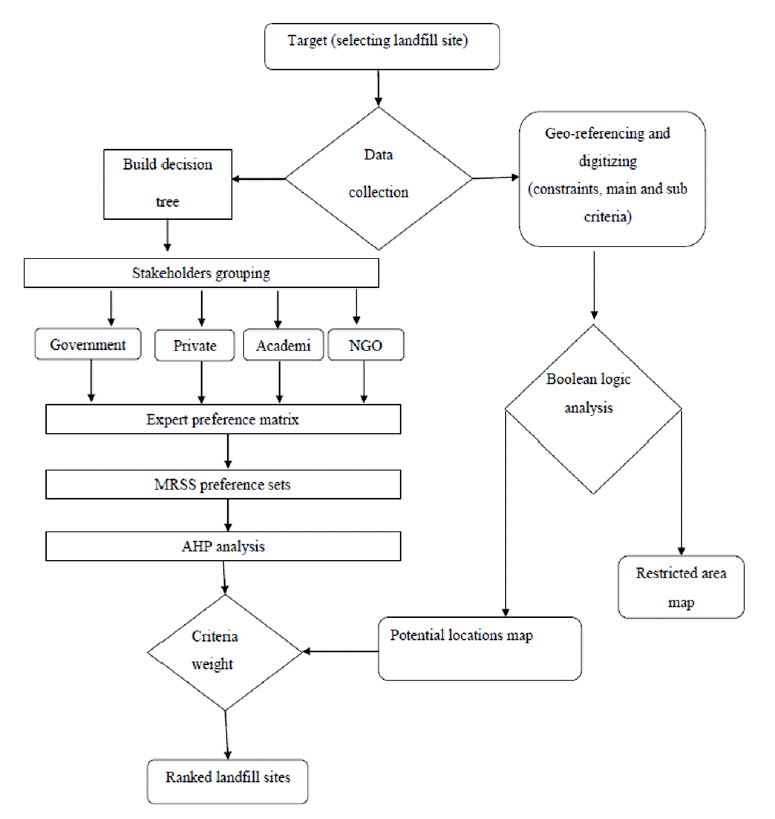
Where, CI, CR, and RI are consistency index, consistency ratio, and random index, respectively. RI can be determined using the tables available in the literature, such as [42], and n is the number of criteria evaluated. The integrated landfill siting procedures (summarized in Fig. 2) illustrate the guidelines for such a decision-making problem. It starts by determining the target followed by building the decision tree. Building the decision tree refers to identifying and grouping the constraints, criteria and stakeholders. The figure also shows the in parallel geo-reference data collecting and processing that is required to suggest the potential landfill locations.
3. Results and Discussion
3.1 Landfill Area Estimation
To estimate the landfill area, the expected solid waste generation per capita per annum was built from 2013 to 2040 using the ARIMA (6,2,1) model for the study area. The model was designed based on the results of autocorrelation and partial autocorrelation diagrams. However, the fluctuation of the original data influenced the forecasting; and thus, the forecasted waste generation also fluctuated, but with less strength. This may have resulted from socio-economical variations. The equation that represents the model is expressed as follows:
Where, yt is the annual solid waste generation rate (kg/capita) at year (t). Table 1 shows the ARIMA (6,2,1) forecast results and the population number for the period 2013 to 2040. The solid waste composition and average density were derived from the literatures. The obtained average solid waste density was equal to 770kg/m3. According to Vision 2020, the planned solid waste disposal scenarios are recycling (22%), composting (8%), incineration (16.3%), inert landfill (9.1%), and sanitary landfill (44.1%) of the total solid waste generated. Consequently, the total required landfill area was calculated using the following assumptions:
The average waste disposal height equals 22 m
The total area required for administration, utilities, and roads equals 40% of the waste disposal area. Therefore, the total landfill area may be calculated using Eq. (8).
3.2. Ranking of Landfill Site Criteria
Criteria that affect landfill siting were divided into four groups, namely operational, social, environmental, and land use; and eleven sub-criteria (as shown in Fig. 1). Seventeen pairwise comparisons were made and ranked as required by MRSS to calculate the importance set of each comparison. An example of one of these comparisons (as shown in Tables 2 and 3) represents the expert’s preferences of the ground water depth and the land topology to maximize the environmental elements protection with respect to landfill site selection. Incorporating the participation of conflicting stakeholders minimizes the uncertainty and risk of reproducing homogenous decisions and enhances the quality of the decisions. Additionally, consistent and reliable results must be achieved [43, 44].
However, due to stakeholder’s conflicts of interest, the expert’s responses range within the set is relatively large. This is clearly shown in the responses of the second expert group, which were (1,1,7,1). Ahmad [45] calculated the geometric mean of the experts judgments and applied them to obtain the expert’s preferences. However, this may lead to inaccurate response representation. Moreover, perfect consistency is difficult to achieve, and CR value should be less than 10% [46]. If the CR value is more than 0.1, the judgment is considered untrustworthy. However, it is not an easy task to collect the expert’s judgments. For instance, in a study conducted by [47], only 25% of the participating experts achieved CR < 0.1. To solve this, the accepted CR was increased to 0.2 to involve more surveyed experts within the study. Then, the results of AHP were applied in the GIS software to obtain the suggested area for each individual expert [47]. However, this was a time consuming approach. In order to manipulate the mentioned limitations, this study suggests arranging the expert’s responses in a four by four matrix (as shown in Table 2) and to rank the responses (as shown in Table 3) and then apply Eq. (4) to obtain the relative importance set of (3; 1; 1; 1). Such a technique guarantees the representation of the best set; regardless of who did the response or to which sector he/she belonged.
In our example, after getting the preference set of (3; 1; 1; 1), an average value was used to determine the best preference value of the comparison between the ground water and the land topology. This value was used in AHP analysis to determine the final priority. Table (4) summarizes the resulted pairwise comparisons and the obtained preference sets for the entire main- and sub-criteria. Meanwhile, Table (5) represents the priorities of main criteria resulted from the AHP analysis. The most important of these criteria is environmental, at 48.1%. Since landfill should be located to minimize impact on the surrounding environment, it is logical to assign the highest rank to the environmental criteria. Moreover, to minimize construction and operational costs and society concern, land use was assigned the second most importance at 21.5%. However, social criteria, which are aesthetics and distance from the nearest settlement, were least important; because it can be extended and modified. Furthermore, the comparison results are accepted since the obtained consistency ratio (0.04) was less than 0.1.
The final priorities of all sub-criteria (as summarized in Table 6) achieve a consistency ratio equal to 0.07. The most important factor is the distance from surface water with an importance equal to 18.0%. This can be justified because surface water is easily polluted and these pollutants can spread fast. The second most important factor is fault zones with relative priority equal to 13.7%. Again, such importance is required to protect the ground water from the impact of leachate. The least important criteria are soil cover availability, landfill area, and distance from the nearest settlement; with relative importance ranks equal to 4.2%, 4.7% and 4.7%, respectively.
Finally, integrating the expert extracted knowledge and MRSS- AHP reduces the uncertainty and risk of reproducing homogenous decisions [36, 44]. Meanwhile, integrating the required landfill area with the criteria ranking enhances the decision. Furthermore, according to the obtained results, we can conclude that the social and operational criteria are considered to be insignificant by the stakeholders, The same conclusion was also reported by Ismail [47] for landfill siting in Malaysia. Moreover, Ismail reported ground, surface water and protected area as the most important factors, followed by land slope [47]. Afzali [19] ranked surface water (19%) followed by ground water (13%) as the most important physical criteria. Nadi [48] ranked hydrology and water as the most important criteria (33.4%) and social and financial as the least important criteria, with weights equal to 15.5% and 15.3, respectively. Demesouka [29] indicated hydrological as the most important factor, followed by environmental criteria, and ranked social and economic factors as least important or insignificant factors. However, it is sometimes inappropriate to compare studies from different countries, because obtained weights are often dependent upon surveyed respondents, different studied factors and different local and environmental conditions.
3.3. Landfill Siting
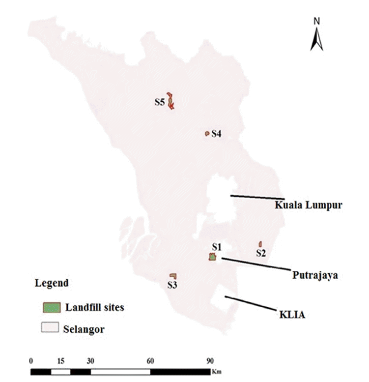
Selangor is the most populated and highly developed state in Malaysia. Its economy is diversified and includes industry, commerce, agriculture and tourism. Moreover, Selangor completely surrounds two federal territories, which are Kuala Lumpur (KL), the national capital of Malaysia, and Putrajaya, the federal capital. The areas of Selangor, Kuala Lumpur and Putrajaya are 7,930, 243 and 92 km2, respectively. However, there is an urgent need to develop a scientific approach for determining a landfill site location in Selangor, due to increasing amounts of solid waste and land scarcity. Therefore, a restrictions map to exclude unsuitable areas that cannot be used for the disposal site because of limiting factors, was built. These factors were based on Malaysian guidelines for development of solid waste sanitary landfill [49]. Fig. 3 shows the landfill restriction areas in Selangor state. All restriction areas were determined using a Boolean operation [50]. It represents around 82% of the total Selangor area.
The potential location areas are shown in green in Fig. 4. However, not all potential areas can be considered for landfill construction, due to size or operational cost constraints. The green area in the top map shows the potential areas that were assigned a value of (1). After determining the potential areas, five sites were determined as potential landfill locations based on their area (size) as shown in Fig. 5. The required landfill area was assumed to be between 100 and 110 hectares. Therefore, three landfills were required to fulfil the land requirement for the generated solid waste. This assumption was based on Agamuthu’s [51] recommendation for minimum landfill size of no less than 60 hectares to economically collect gas, and Soek’s [52] recommendation for potential impacts of large landfill sizes. The ranks of the potential landfill sites are shown in Table (7). These ranks were obtained using the results of the MRSS-AHP model for site evaluation criteria and Suitability Index (SI) i.e., the sum of products of the standardized score of each criterion multiplied by the weight of each criterion.
4. Conclusions
For landfill siting, it is essential to determine the site evaluation criteria and build the dependences among them. Moreover, landfill sizing should be based on reliable waste generation prediction to justify the required area. The resulted rank is logical and justifies the demand to protect the environmental elements. For landfill siting, the main concern is to maximize environmental elements protection, due to their direct effect on human life and high treatment costs. Next is land use, which is related to investment cost and future plans. Strategic planning requires special consideration of population growth, city expansion, and public service utilization, like landfill. The least important criterion is social, because social issues related to landfill sites can be minimized by proper management and communication with local societies. However, the proposed criteria priorities determinations may serve as a reference point for future complex decision making issues, because they involve extracting expert knowledge using MRSS and AHP.